Filtered by:
- Category
- List
- Grid
A subscription to the Price Guide is required to view results for auctions ten days or older. Click here for more information
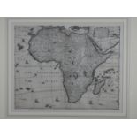

Africa. Speed (John), Africae. A framed and glazed 17th century map of Africae engraved by Abraham
Africa. Speed (John), Africae. A framed and glazed 17th century map of Africae engraved by Abraham Goos. Text verso.
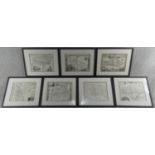
Seven framed and glazed antique engraved maps of various places in Great Britain. Sussex, Isle of
Seven framed and glazed antique engraved maps of various places in Great Britain. Sussex, Isle of Thanet, Cambridge, Isle of Man, Surrey, Portsmou...
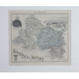
A Framed and glazed antique map of Bouches Du Rhone. Gravé par Barbier and Waltner. Illustrated
A Framed and glazed antique map of Bouches Du Rhone. Gravé par Barbier and Waltner. Illustrated details. 40x39cm.

A framed and glazed 18th century antique map of Denmark. Titled 'Il Regno di Danimarca, con il
A framed and glazed 18th century antique map of Denmark. Titled 'Il Regno di Danimarca, con il Ducato di Sleswik di nuova projezione' by Antonio Z...
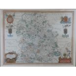
A framed and glazed antique hand coloured map of Shropshire. Comitatus Salopiensis, Shropshire. By
A framed and glazed antique hand coloured map of Shropshire. Comitatus Salopiensis, Shropshire. By Jan Blaeu. 64x51cm.

A framed and glazed 18th century sectional map of Kent by Andrews, Drury & Herbert. A plated from 'A
A framed and glazed 18th century sectional map of Kent by Andrews, Drury & Herbert. A plated from 'A Topographical Map of The County of Kent in 25...
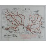
A framed and glazed vintage map of Jersey by the Jersey Transport Company. With illustrated details.
A framed and glazed vintage map of Jersey by the Jersey Transport Company. With illustrated details. Published by New Centurion publishing and pub...