Filtered by:
- Category
- List
- Grid
A subscription to the Price Guide is required to view results for auctions ten days or older. Click here for more information


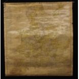
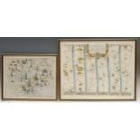
A George III needlework sampler, Map of England and Wales, by Frances Stockdale, Lincoln 178752cm
A George III needlework sampler, Map of England and Wales, by Frances Stockdale, Lincoln 178752cm x 48.5cm
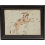
Astronomy - Rev. Richard Bloxam, a star chart, Lynx and Telescopium Herschilii, From Urania?s
Astronomy - Rev. Richard Bloxam, a star chart, Lynx and Telescopium Herschilii, From Urania?s Mirror, or a View of the Heavens, Samuel Leigh, Lond...
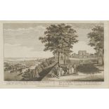
Luke Sullivan (1705 - 1771), a pair, A View of Cliefden in Buckinghamshire, the Seat of the Rt Hon
Luke Sullivan (1705 - 1771), a pair, A View of Cliefden in Buckinghamshire, the Seat of the Rt Hon the Earl of Inchiquin and A View of Woobourn in...
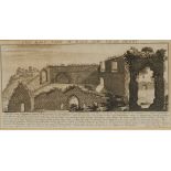
Samuel Buck (1696-1779) and Nathaniel Buck (fl. 1724-1759), The East View of Dale Abby (sic), Near
Samuel Buck (1696-1779) and Nathaniel Buck (fl. 1724-1759), The East View of Dale Abby (sic), Near Derby, from Views of Ruins of Castles & Abbeys ...
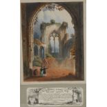
Topographical Novelty - Reeves & Sons and W Morgan, a litograph transparency, C W's Dioramic
Topographical Novelty - Reeves & Sons and W Morgan, a litograph transparency, C W's Dioramic Views, No.3, Netley Abbey, 19cm x 15cm, c.1840 ...[...
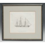
William John Huggins, after, The James Watt Steam Ship, monochrome print, published Jan 1st 1824,
William John Huggins, after, The James Watt Steam Ship, monochrome print, published Jan 1st 1824, 26cm x 31cm

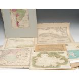
Cartography - a collection of 17th century and later maps of GB, Europe, and World, including
Cartography - a collection of 17th century and later maps of GB, Europe, and World, including Ireland, Gerardus Mercator (1512-1594), Irlandiae Re...
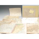
Cartography - a large and miscellaneous collection of early 19th century and later maps, comprising GB and regions, European countries and states,...
Cartography - an early 20th century wall chart, Scarborough's map of England and Wales shewing
Cartography - an early 20th century wall chart, Scarborough's map of England and Wales shewing geographical counties and boroughs : all railways a...
Cartography, the Americas and the Caribbean - George Washington Boynton (American, fl. c. 1830 -
Cartography, the Americas and the Caribbean - George Washington Boynton (American, fl. c. 1830 - 1850), map of the West Indies, Entered [...] in t...
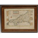
Herman Moll, an engraved and coloured two-page map, Cornwall, the border with vignettes of antiquities of the county, 23.5cm x 34cm
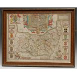
John Speed & John Norden, a two-page coloured map, Essex Divided into Hundreds with the Most Ancient
John Speed & John Norden, a two-page coloured map, Essex Divided into Hundreds with the Most Ancient and Fayre Towne Colchester described [...] An...
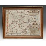
John Speed, an engraved and coloured two-page map, Suffolk, described and divided into Hundreds, the
John Speed, an engraved and coloured two-page map, Suffolk, described and divided into Hundreds, the situation of the fayre town Ipswich..... unda...
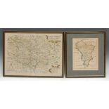
Michael Drayton (1563 - 1631) and William Hole , a two page coloured map, Derbyshire, Nottinghamshire and Leicestershire, plate 115 from Drayton's...
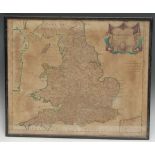
Robert Morden, an engraved and coloured two-page map, England, 37cm x 44.5cm
Thomas Jefferys, an engraved map, A New and Correct Chart of Europe, 35cm x 41.5cm; William Kip (
Thomas Jefferys, an engraved map, A New and Correct Chart of Europe, 35cm x 41.5cm; William Kip (1588-1635), after Christopher Saxton (c. 1540 ? c...
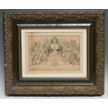
British Politics - a memorial card, issued to W Woodward, a subscriber to the Liberal monument
British Politics - a memorial card, issued to W Woodward, a subscriber to the Liberal monument errected within the Palace of Westminster to Willia...
Science, the Enlightenment & 19th Century Discovery - Association Copies, 8 monographs and academic extracts presented by their authors to Admiral...