Verfeinern Sie Ihre Suche
Auktionshaus-Kategorie
Schätzpreis
Kategorie
Filter entfernen- Landkarten (79)
Künstler / Marke
- Mercator (5)
- Robert Sayer (4)
- Blaeu (3)
- Edward Stanford (3)
- George Philip and Son (3)
- John Bowles and Son (3)
- Depot Generale de la Marine (2)
- John Bartholomew (2)
- John Tallis (2)
- Charles Price (1)
- Edward Weller (1)
- J H Colton (1)
- Jacques Nicholas Bellin (1)
- James Imray (1)
- James Imray and Son (1)
- John Cary (1)
- John Senex (1)
- Le Rouge (1)
- Leslie George Bullock (1)
- London Magazine (1)
- Mynde (1)
- Ortelius (1)
- Rigobert Bonne (1)
- Robert Wilkinson (1)
- The Corporation of Trinity House (1)
- Thomas Kitchin (1)
- W Rose (1)
- William Faden (1)
Lostyp
Sortieren nach:
- Kategorie
- Liste
- Galerie
Ein Abonnement der Preisliste ist notwendig um Ergebnisse, von Auktionen die vor einem längeren Zeitraum als 10 Tagen stattgefunden haben, ansehen zu können. Klicken Sie hier für mehr Informationen
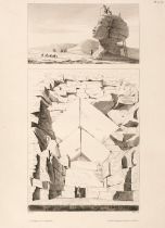

Denon (Dominique Vivant). Planches du voyage dans la Basse et la Haute Egypte, atlas only, 1829
Denon (Dominique Vivant). Planches du voyage dans la Basse et la Haute Egypte, atlas volume only, Paris: Henri Gaugain & Chaillou, 1829, 143 engra...
![Tassin (Christophe). Plans et Profilz des Principales villes..., [1638]](https://portal-images.azureedge.net/auctions-2024/srdom10237/images/aa98291d-05b0-4294-bd27-b16200a89cfd.jpg?h=210)
Tassin (Christophe). Plans et Profilz des Principales villes de la province de Champagne, avec la carte generale & les particulieres de chascun go...
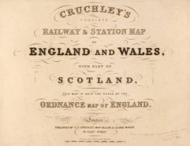
Cruchley (G. K. publisher). Cruchley's Complete Railway & Station Map of England and Wales, with Part of Scotland, This Map is Half the Scale of t...
Grose (Francis). A New and Complete Abridgment or Selection of the Most Interesting and Important Subjects in The Antiquities of England and Wales...
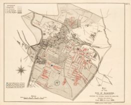
Small-Pox Vaccination Maps. Gloucester and Warrington, London: Her Majesty's Stationery Office,
Small-Pox Vaccination Maps. Appendix VII to the Final Report of the Royal Commission on Vaccination. Report to the Commission of Dr. Sidney Coupla...
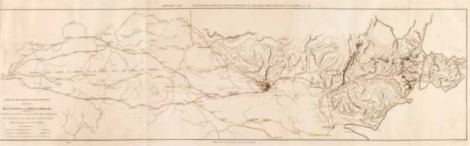
Wales. Reports from Committees on Holyhead Roads, Harbours &c in the Years 1810, 1811, 1815, 1816, 1817, 1819, 1820 and 1822 [communicated by the ...
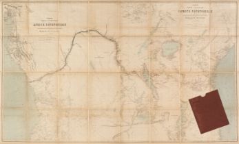
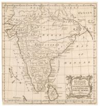
Africa. Treves (Fratelli, publisher), Carta Parte Orientale dell Africa Equatoriale..., 1880
Africa. Treves (Fratelli, publisher), Carta Parte Orientale dell Africa Equatoriale e dell Esplorazioni per Terra e per Acqua di Entico M. Stanley...
![Asia. Mercator (Gerard), Asia ex Magna Orbis Terre Descriptione..., [1604 or later]](https://portal-images.azureedge.net/auctions-2024/srdom10237/images/bdf2e6b4-17eb-4d53-8c9c-b16200a8b52d.jpg?h=210)
* Asia. Mercator (Gerard), Asia ex Magna Orbis Terre Descriptione Gerardi Mercatoris Desumpta, Studio et Industria G.M. Iunioris [1604 or later], ...
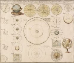
* Astronomy. (Homann Johann Baptist, heirs of), Schematismus Geographiae Mathematicae, id est repraesentatio figurarum in quantum ad aliqualem glo...
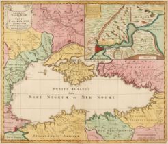
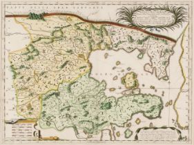
Black Sea. Lotter (T. C.). Nova Mappa Maris Nigri et Freti Constantino Politani..., circa 1750
Black Sea. Lotter (Tobias Conrad), Nova Mappa Maris Nigri et Freti Constantino Politani..., Augsburg, circa 1750, engraved map with contemporary w...
Bonne (Rigobert). [Atlas Encyclopedique, Contenant la Geographie Ancienne, et quelques Cartes sur la Geographie du Moyen Age, la Geographie Modern...
Bowen (Emanuel & Owen John). Britannia Depicta: Or Ogilby Improved...., Carington Bowles, 1764
Bowen (Emanuel & Owen John). Britannia Depicta or Ogilby Improv'd; being an Actual Survey of all the direct and Principal Cross Roads of England a...
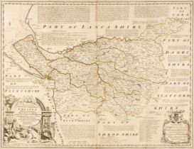
Bowen (Emanuel). An Accurate Map of the County Palatine of Chester, Divided into its Hundreds..., J & C Bowles and Robert Sayer, circa 1765, engra...
![British Isles. Jaillot (Alexis Hubert), Les Isles Britannique..., [1695]](https://portal-images.azureedge.net/auctions-2024/srdom10237/images/ec5bb899-5578-42b2-a284-b16200a8b8b1.jpg?h=210)
British Isles. Jaillot (Alexis Hubert), Les Isles Britannique qui contiennent les Royaumes d'Angleterre Escosse, et Irlande..., Amsterdam [1695], ...
![British Isles. Jaillot (Alexis Hubert), Les Isles Britannique..., [1696]](https://portal-images.azureedge.net/auctions-2024/srdom10237/images/7a47e6a6-6fe6-40b6-ab4c-b16200a8b933.jpg?h=210)
British Isles. Jaillot (Alexis Hubert), Les Isles Britannique qui contiennent les Royaumes d'Angleterre Escosse, et Irlande..., Amsterdam [1696], ...
![British Isles. Jansson (Jan), Pascaart Vant Canaal Tusschen Engelandt..., [1650]](https://portal-images.azureedge.net/auctions-2024/srdom10237/images/70153f2f-5342-4b19-ba8b-b16200a8b99b.jpg?h=210)
British Isles. Jansson (Jan), Pascaart Vant Canaal Tusschen Engelandt en Vrancryck alsmede geheel Ierlant en Schotlant..., Amsterdam [1650], engra...
British Isles. Janvier (Jean), Les Isles Britanniques Comprenant les Royaumes D'Angleterre, D'Ecosse et D'Irlande, Divisés en Grandes Provinces, S...
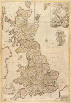
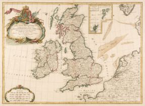
British Isles. Senex (John), A New Map of Great Britain, Corrected from the Observations communicated to the Royal Society at London, 1728, engrav...
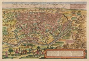
Cairo. Braun (Georg & Hogenberg Frans), Cairus, quae olim Babylon; Aegypti Maxima Urbs, circa 1572
* Cairo. Braun (Georg & Hogenberg Frans), Cairus, quae olim Babylon; Aegypti Maxima Urbs [1572 - 1618], engraved map with contemporary hand-colour...
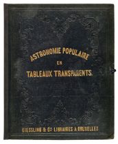
Celestial Charts. Twelve Plans and Charts of Celestial Phenomena, Astronomie Populaire en Tableaux Transparents (title printed on upper siding). F...
* China. Coronelli (Vicenzo Maria), Xantung e Peking Provincie della China...., Venice, circa 1690, hand-coloured engraved map, decorative cartouc...
![China. Mercator (Gerard), China, [1606 or later]](https://portal-images.azureedge.net/auctions-2024/srdom10237/images/b4719eb4-4639-442d-9842-b16200a8bd29.jpg?h=210)
* China. Mercator (Gerard), China, [1606 or later], hand-coloured engraved map, 345 x 465 mm, mounted, framed and glazedQTY: (1)NOTE:A decorative ...
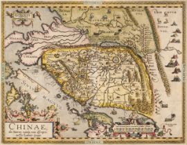
China. Ortelius (Abraham), Chinae olim Sinarum regionis nova descriptio..., Antwerp [1592 or
* China. Ortelius (Abraham), Chinae olim Sinarum regionis nova descriptio, auctore Ludovico Georgio, Antwerp [1592 or later], hand-coloured engrav...
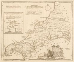
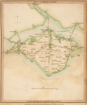
![Cornwall. Kip (William), Cornwall olim pars Danmoniorum [1610]](https://portal-images.azureedge.net/auctions-2024/srdom10237/images/2a6a8956-10ac-4f68-8388-b16200a8bea5.jpg?h=210)
Cornwall. Kip (William), Cornwall olim pars Danmoniorum [1610], hand-coloured engraved map, large inset vignette of Launceston, narrow vertical ma...
D'Anville (Jean Baptiste). Atlas with 30 engraved maps, circa 1714-64, lacking title, 30 engraved maps (mostly 2 sheet, 4 folding), the majority w...
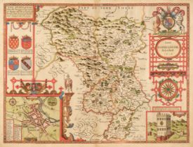
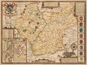
Derbyshire. Speed (John), Anno Darbieshire described, J. Sudbury & George Humble, circa 1627
Derbyshire. Speed (John), Anno Darbieshire described, J. Sudbury & George Humble, circa 1627, hand-coloured engraved map, inset town plan of Derby...
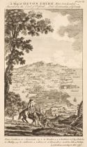
Devon. Bickham (G.), A Map of Devon - Shire West from London..., 1750, uncoloured 'birds-eye' map with text above and below the image, 260 x 160 m...
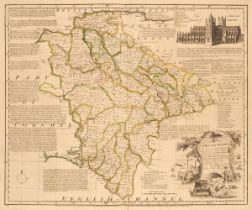
Devon. Bowen (Emanuel), An Accurate Map of Devon Shire, Divided into its Hundreds, Drawn from the best Authorities..., John Bowles & Sons, Messrs ...
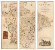
Devon. Greenwood (C. & J.), Map of the County of Devon from an Actual Survey, made in the Years 1825 & 1826 by C. & J. Greenwood, most Respectfull...
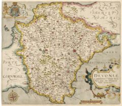
Devon. Saxton (Christopher & Kip Wlliam), Devoniae Comitatus vulgo Denshyre quam olim Danmonii Populi Incolouerunt, [1637], hand-coloured engraved...
![East Indies. Jansson (Jan), Indiae Orientalis Nova Descriptio, [1635 or later]](https://portal-images.azureedge.net/auctions-2024/srdom10237/images/a7ee968f-9ad8-47c1-9880-b16200a8c1e6.jpg?h=210)
* East Indies. Jansson (Jan), Indiae Orientalis Nova Descriptio, Amsterdam [1635 or later], hand-coloured engraved map, decorative cartouche and m...
England & Europe. A collection of approximately 80 maps, mostly 19th & 20th-century, engraved maps, road maps, siege maps, town plans, pedigrees a...
![England and Wales. Geological Map of England & Wales. London: Dobbs & Co., [1843]](https://portal-images.azureedge.net/auctions-2024/srdom10237/images/b42395df-0b6a-4c20-a618-b16200a8c2bf.jpg?h=210)
England and Wales. Dobbs & Co.'s Relievo Maps, Drawn & Engraved from the Highest Official Authorities. Geological Map of England & Wales. Arranged...
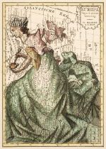
Europe. Bohn (F.), Europa Volgens de Nieuwste Verdeeling, Haarlem, circa 1794, engraved allegorical map with contemporary wash colouring, old fold...
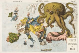
Europe. Grossi (Augusto), La Piovra Russa, published Papagallo - Le Perroquet Magazine, 1878
Europe. Grossi (Augusto), La Piovra Russa, Carta Serio-Comica, published Bologna, Papagallo - Le Perroquet Magazine, 14th April 1878, an allegoric...
Folding maps. A collection of 10 folding maps of towns/ boundaries in England, mostly 19th-century
Folding maps. A collection of 10 folding maps of towns/boundaries in England, mostly 19th century, including Mogg (William publisher). Map of the ...
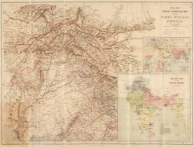
Folding maps. A collection of 6 folding maps of foreign parts, mostly 19th-century, including Philips's Special Large Scale Map of the North Weste...
Foreign Maps. A collection of approximately 70 maps, mostly 19th & 20th-century, engraved maps, views, pedigrees and others, mostly uncoloured, in...
Greenville Collins (Captain). Great Britain's Coasting Pilot..., J. & W. Mount & T. Page, 1779
Greenville Collins (Captain). Great Britain's Coasting Pilot, Being a new and Exact Survey of the Sea-Coast of England and Scotland, from the Rive...
Hampshire. Speed (John), Hantshire described and devided, Thomas Bassett & Richard Chiswell, 1676
* Hampshire. Speed (John), Hantshire described and devided, Thomas Bassett & Richard Chiswell [1676], uncoloured engraved map, inset town plan of ...
* Homann (Johann Baptiste). Planiglobii Terrestris Cum Utroq Hemisphaerio Caelesti Generalis Exhibitio..., Nuremberg, circa 1715, hand-coloured en...
![Ireland. Van Loon (H.), Carte Generale des Costes D'Irlande..., [1661 or later]](https://portal-images.azureedge.net/auctions-2024/srdom10237/images/ad6f2392-25ec-444a-9fc1-b16200a8c8db.jpg?h=210)
Ireland. Van Loon (Hermanus.), Carte Generale des Costes D'Irlande et des Costes Occidentales D'Angleterre avec une Partie de celles D'Ecosse, [16...
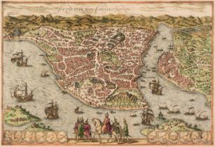
* Istanbul. Braun (Georg & Hogenberg Franz), Byzantium Nunc Constantinopolis, Cologne, circa 1580, engraved map with contemporary hand-colouring, ...
* Jakarta. Homann (Johann Baptist, heirs of), Der Hollaendisch - Ostindianischen Compagnie Weltberühmte Haupt-Handels Niederlags - Stadt Batavia i...
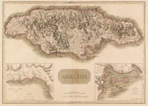
Jamaica. Thomson (John), Jamaica, circa 1817, double-page map engraved by T. Clerk with contemporary outline colouring, inset maps of the Harbours...
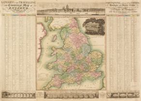
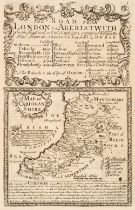
Langley (Edward & Belch William). Langley's new travelling and commercial map of England..., 1817
Langley (Edward & Belch William). Langley's New Travelling and Commercial Map of England and Wales. Containing a list of all the Cities, Boroughs ...
Laurie (Robert & Whittle, James). Laurie and Whittle's New Traveller's Companion, Exhibiting a Complete and Correct Survey of all the Direct and P...
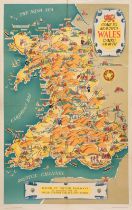
Lee (Kerry). Come to Beautiful Wales, Cymru am Byth, Railway Executive (publisher), circa 1953
Lee (Kerry). Come to Beautiful Wales, Cymru am Byth, Railway Executive - London Midland Region - (publisher), printed by McCorquodale & Co. Ltd, c...
* Leicestershire. Speed (John), Leicester both countye and Citie described, The Honorable famylies that have had the titles of Earls thereof. With...
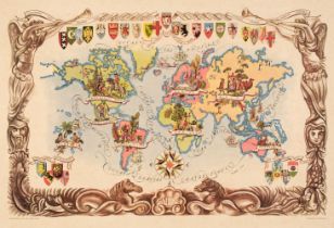
Liozu (Jacques). Eight Pictorial Maps, Untitled Map of the World (on Mercator's projection), Europe Occidentale, Amérique du Sud, Amérique du Nord...
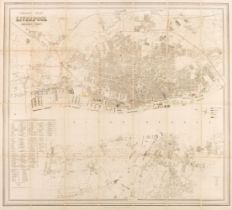
Liverpool. George Phillips' Plan of Liverpool and the Surrounding Cheshire Coast, Compiled from Actual Surveys, circa 1880, uncoloured folding lit...
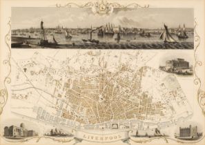
* Liverpool. Rapkin (J.), Liverpool, John Tallis & Company, circa 1850, hand-coloured engraved double-page city plan, inset vignettes, large panor...
London. A collection of approximately 140 maps and prints, mostly 19th & 20th-century, engraved maps, views, plans and road maps of London, London...
London. Gill (Leslie MacDonald), Pictorial Map of Central London, Waterlow and Sons Ltd. 1932, large chromolithographic map with lines of verse to...
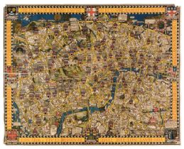
London. Gill (MacDonald). Wonderground Map of London Town, The Westminster Press, circa 1928
London. Gill (MacDonald). Wonderground Map of London Town, The Westminster Press, circa 1924, photolithographic colour printed map, long closed te...
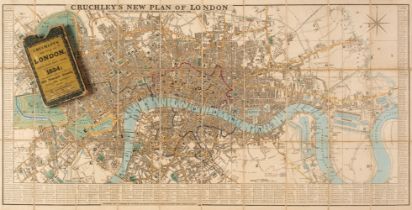
London. Cruchley (George Frederick), Cruchley's New Plan of London Shewing all the New and Intended Improvements to the Present Time, 1834, engrav...
Maps. A collection of 13 maps, 17th - 19th century, engraved and lithographic British county and foreign maps, including examples by or after Matt...
Maps. A collection of approximately 200 maps, 18th & 19th century, engraved and lithographic British and foreign maps, including examples by or af...
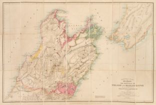
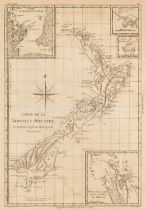
New Zealand. Stanford's Atlas of New Zealand, the Provinces of Nelson and Malbrough with the adjacent parts of Wellington and Canterbury..., Londo...
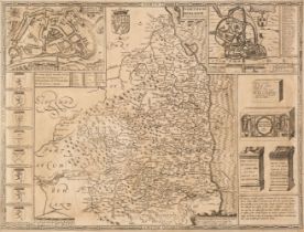
* Northumberland. Speed (John), Northumberland, John Sudbury & George Humble [1611 or later], uncoloured engraved map, inset town plans of Berwick...